Church Area0001
Originally uploaded by Port Tobacco Archaeological Project
As I consider further the Colonial cemetery that we uncovered in June and the prospects of finding the Anglican church, it seems prudent to reevaluate some of our shovel test pit data from last October. Afterall, it was on the basis of that data that we suspected a cemetery and that we identified other promising locations for finding intact archaeological remains.
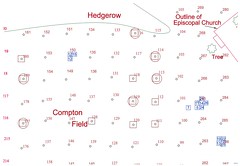
This map (click on it for a larger image) shows the three units that uncovered the four graves and paling fence ditch, as well as the shovel tests that we excavated the previous year. (The squares to the right tested the aboriginal locus and the Wade House/Centennial Hotel locus.) I drew circles around each of the shovel tests that yielded large quantities of brick rubble (over 150 ounces) and the squares represent shovel tests that produced a larger than average number of handwrought and indeterminate type nails (eight or more per unit).
The nail and brick clusters are north and south of the cemetery area, and slightly east. Both clusters warrant additional testing with 5 ft by 5 ft excavation units and, of course, we should further expose graveshafts and follow the fence ditch; all with property owner's permission. Hopefully we can start the effort in late October or November, funding permitted.
Jim


No comments:
Post a Comment